In my observatory I use:
* 3 different home positions according to the mounted OTA
* 2 different FLAT positions for natural and illuminated panel flats
I had the need of being able to tell my mount to GOTO all this diferrent AltAz coordinates, so I scripted it.
Any improvement appreciated
Code: Select all
import time

clr.AddReference("SharpCap.ImageProcessing")
clr.AddReference("SharpCap")
clr.AddReference('System.Windows.Forms')
clr.AddReference('System.Drawing')

from SharpCap.ImageProcessing import SkyCoordConverter
from datetime import datetime
from System.Windows.Forms import *
from System.Drawing import Point, Color, Font, FontStyle, Size, Image, Icon

#TELESCOPE COORDINATES
latitude = 40.459583
longitude = -3.799660

class MoveToAltAz(Form):

	def __init__(self):
		self.Text = "NTO GotoAltAz"
		self.TopMost = True
		self.Width = 246
		self.Height = 240
		self.BackColor = Color.FromName("Black")
		self.ForeColor = Color.FromName("Orange")

		self.actualRaDec = Label()
		self.actualRaDec.Text = "RA=00:00:00DEC=00:00:00N"
		self.actualRaDec.Location = Point(10, 10)
		self.actualRaDec.Font = Font(self.actualRaDec.Font, FontStyle.Bold)
		self.actualRaDec.ForeColor = Color.FromName("Green")
		self.actualRaDec.AutoSize = True
		self.actualRaDec.DoubleClick += self.refrescar_posicion

		self.actualAltAz = Label()
		self.actualAltAz.Text = "Alt=00:00:00Az=00:00:00"
		self.actualAltAz.Location = Point(10, 40)
		self.actualAltAz.Font = Font(self.actualAltAz.Font, FontStyle.Bold)
		self.actualAltAz.ForeColor = Color.FromName("Green")
		self.actualAltAz.AutoSize = True
		self.actualAltAz.DoubleClick += self.refrescar_posicion

		self.labelTARGET = Label()
		self.labelTARGET.Text = "Target"
		self.labelTARGET.Location = Point(10, 70)
		self.labelTARGET.AutoSize = True

		self.TARGET = ComboBox()
		self.TARGET.Items.Add("HOME CN")
		self.TARGET.Items.Add("HOME C11")
		self.TARGET.Items.Add("HOME REF")
		self.TARGET.Items.Add("FLAT NAT")
		self.TARGET.Items.Add("FLAT SCREEN")
		self.TARGET.Location = Point(56, 70)
		self.TARGET.Width = 164
		self.TARGET.SelectedIndexChanged += self.cambiar_combo

		self.labelALT = Label()
		self.labelALT.Text = "Altitude"
		self.labelALT.Location = Point(10, 100)
		self.labelALT.AutoSize = True

		self.ALT = TextBox()
		self.ALT.Text = "0.0000"
		self.ALT.Location = Point(56, 100)
		self.ALT.Width = 54

		self.labelAZM = Label()
		self.labelAZM.Text = "Azimuth"
		self.labelAZM.Location = Point(120, 100)
		self.labelAZM.AutoSize = True

		self.AZM = TextBox()
		self.AZM.Text = "230.0000"
		self.AZM.Location = Point(166, 100)
		self.AZM.Width = 54

		self.labellabelRA = Label()
		self.labellabelRA.Text = "RA"
		self.labellabelRA.Location = Point(10, 130)
		self.labellabelRA.AutoSize = True

 		self.labelRA = Label()
		self.labelRA.Text = "0.0000"
		self.labelRA.Location = Point(56, 130)
		self.labelRA.AutoSize = True

		self.labellabelDEC = Label()
		self.labellabelDEC.Text = "DEC"
		self.labellabelDEC.Location = Point(120, 130)
		self.labellabelDEC.AutoSize = True

		self.labelDEC = Label()
		self.labelDEC.Text = "0.0000"
		self.labelDEC.Location = Point(166, 130)
		self.labelDEC.AutoSize = True

		self.CALC = Button()
		self.CALC.Text = 'Calculate'
		self.CALC.Width = 100
		self.CALC.Height = 30
		self.CALC.Location = Point(10, 160)
		self.CALC.Font = Font(self.CALC.Font, FontStyle.Bold)
		self.CALC.Click += self.calculate_RaDec

		self.GOTO = Button()
		self.GOTO.Text = 'GOTO'
		self.GOTO.Width = 100
		self.GOTO.Height = 30
		self.GOTO.Location = Point(120, 160)
		self.GOTO.Font = Font(self.GOTO.Font, FontStyle.Bold)
		self.GOTO.Click += self.goto_RaDec

		self.Controls.Add(self.actualRaDec)
		self.Controls.Add(self.actualAltAz)
		self.Controls.Add(self.labelTARGET)
		self.Controls.Add(self.TARGET)
		self.Controls.Add(self.labelALT)
		self.Controls.Add(self.ALT)
		self.Controls.Add(self.labelAZM)
		self.Controls.Add(self.AZM)
		self.Controls.Add(self.labellabelRA)
		self.Controls.Add(self.labelRA)
		self.Controls.Add(self.labellabelDEC)
		self.Controls.Add(self.labelDEC)
		self.Controls.Add(self.CALC)
		self.Controls.Add(self.GOTO)

		SharpCap.Mounts.SelectedMount.Connected = True

		self.refrescar_posicion()

	def OnFormClosing(self, e, *args):
		e.Cancel = True
		form.Hide()

	def refrescar_posicion(self, *args):

		ahora = datetime.now()

		scc = SkyCoordConverter(latitude,longitude)
		coordAltAz = scc.DoCoordTransform(0,0,0)

		coordAltAz.Altitude = SharpCap.Mounts.SelectedMount.Altitude
		coordAltAz.Azimuth = SharpCap.Mounts.SelectedMount.Azimuth
		self.actualAltAz.Text = coordAltAz.ToString()

		coordRaDec = scc.ConvertAltAzToRADec(coordAltAz,ahora)
		self.actualRaDec.Text = coordRaDec.ToString()

	def cambiar_combo(self, *args):

		if self.TARGET.SelectedIndex is 0:
			self.ALT.Text = "0.0000"
			self.AZM.Text = "230.0000"

		if self.TARGET.SelectedIndex is 1:
			self.ALT.Text = "0.0000"
			self.AZM.Text = "180.0000"

		if self.TARGET.SelectedIndex is 2:
			self.ALT.Text = "0.0000"
			self.AZM.Text = "230.0000"

		if self.TARGET.SelectedIndex is 3:
			self.ALT.Text = "90.0000"
			self.AZM.Text = "90.0000"

		if self.TARGET.SelectedIndex is 4:
			self.ALT.Text = "10.0000"
			self.AZM.Text = "200.0000"

	def calculate_RaDec(self, *args):

		altitude = float(self.ALT.Text)
		if altitude is None: return
		azimuth = float(self.AZM.Text)
		if azimuth is None: return

		ahora = datetime.now()

		scc = SkyCoordConverter(latitude,longitude)
		coordAltAz = scc.DoCoordTransform(0,0,0)
		coordAltAz.Altitude = altitude
		coordAltAz.Azimuth = azimuth
		coordRaDec = scc.ConvertAltAzToRADec(coordAltAz,ahora)
		self.labelRA.Text = "{:.4f}".format(coordRaDec.RightAscension)
		self.labelDEC.Text = "{:.4f}".format(coordRaDec.Declination)

	def goto_RaDec(self, *args):

		if self.GOTO.Text is 'STOP':
			SharpCap.Mounts.SelectedMount.Stop()

		else:
			altitude = float(self.ALT.Text)
			if altitude is None: return
			azimuth = float(self.AZM.Text)
			if azimuth is None: return
			rightascension = float(self.labelRA.Text)
			if rightascension is None: return
			declination = float(self.labelDEC.Text)
			if declination is None: return

			self.actualRaDec.ForeColor = Color.FromName("Red")
			self.actualAltAz.ForeColor = Color.FromName("Red")

			self.GOTO.Text = 'STOP'
			self.GOTO.ForeColor = Color.FromName("Red")
			PAUSE = 1

			SharpCap.Mounts.SelectedMount.SlewTo(rightascension, declination)

#			while SharpCap.Mounts.SelectedMount.Altitude > (altitude + 2) or SharpCap.Mounts.SelectedMount.Altitude < (altitude - 2):
#				while SharpCap.Mounts.SelectedMount.Azimuth > (azimuth + 2) or SharpCap.Mounts.SelectedMount.Azimuth < (azimuth - 2):

			scc = SkyCoordConverter(latitude,longitude)
			coordAltAz = scc.DoCoordTransform(0,0,0)
			while SharpCap.Mounts.SelectedMount.Slewing:
				ahora = datetime.now()
				coordAltAz.Altitude = SharpCap.Mounts.SelectedMount.Altitude
				coordAltAz.Azimuth = SharpCap.Mounts.SelectedMount.Azimuth
				self.actualAltAz.Text = coordAltAz.ToString()
				coordRaDec = scc.ConvertAltAzToRADec(coordAltAz,ahora)
				self.actualRaDec.Text = coordRaDec.ToString()

				Application.DoEvents()
				time.sleep(PAUSE)

		self.actualRaDec.ForeColor = Color.FromName("Green")
		self.actualAltAz.ForeColor = Color.FromName("Green")
		self.GOTO.Text = 'GOTO'
		self.GOTO.ForeColor = Color.FromName("Orange")
		self.refrescar_posicion()


form = MoveToAltAz()
form.Icon = Icon("C:\Program Files (x86)\SharpCap 3.2\Icons\AltAz_icon.ico")

def show_script():
    form.Show()

SharpCap.AddCustomButton("GOTO AltAz", Image.FromFile("C:\Program Files (x86)\SharpCap 3.2\Icons\AltAz_icon.ico"), None, show_script)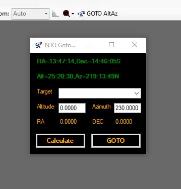
http://nto.org.es/SHARED_GLOBAL/DialogAltAz.JPG
